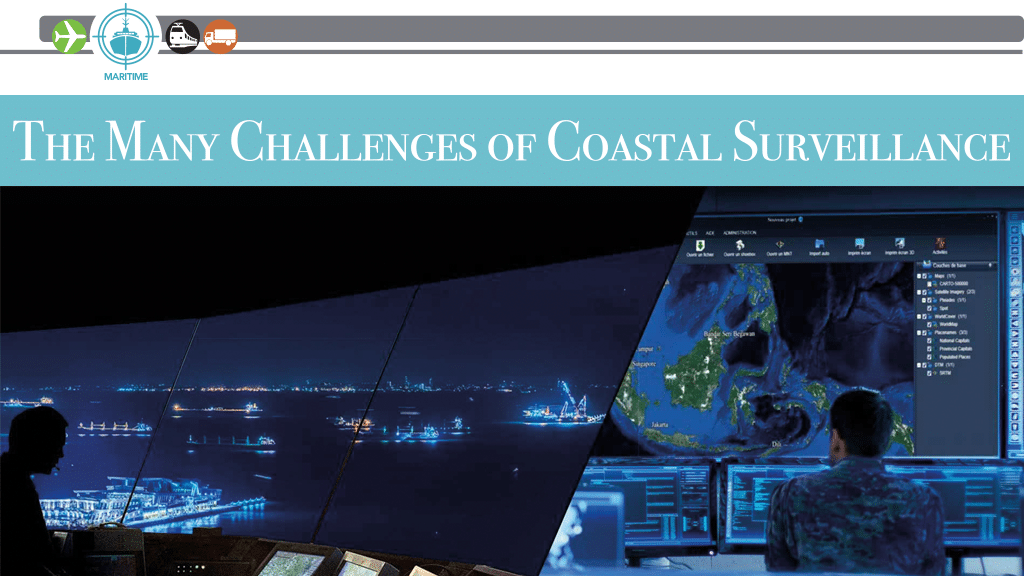
According to NASA, there is about 372,000 miles (620,000 kilometers) of ocean coastline on planet Earth. That’s a lot of territory for customs, coast guards and military organizations to monitor and protect against unwanted intrusions. Put another way: there is more coastline on this planet than there is distance between the Earth and Moon. The distance between Earth and the Moon is a mere 238,855 miles (384,000 km) — a third less in length!
To safeguard their coastlines, many nations turn to corporations who specialize in coastal surveillance, among other things. One of these companies is Airbus Defence and Space (airbus.com). For over 50 years, Airbus has helped monitor and protect some of the world and most critical maritime passages such as the Malacca Strait, the Panama Canal and the Suez Canal.
Coastal surveillance “plays a critical role in managing and controlling a country’s territorial waters and economic exclusive zones,” said Alexis Latty, retired French Navy rear-admiral and an Airbus key account manager. “Moreover, it is a crucial aspect in maintaining national security, safeguarding maritime interests, and upholding law and order at sea.”
HGH (hgh-infrared.com) is another company that aids in coastal surveillance, namely through its portfolio of electro-optics and infrared sensing products. Like Airbus, HGH deploys “solutions all around the world to meet a range of coastal surveillance needs,” said Edouard Campana, HGH’s product line manager.
A Wide Array of Threats
The task of coastline surveillance is made more difficult by the wide array of threats confronting security officials worldwide. To put it mildly, the challenges facing these officials are incredibly varied and consistently challenging.
To add to the problem, there are two categories encompassed by coastal surveillance: “Maritime border protection (sea surveillance), and migration prevention by protecting people from drowning and/or leaving their country (land surveillance),” Campana said. For instance, countries who share maritime borders with impoverished or at-war nations, are “deeply concerned as that population wishes to emigrate by crossing the border in makeshift boats.”
When it comes to sea surveillance — protecting nations from threats coming to their shores, Airbus’ Latty cites six main areas of concern for security officials. They are human trafficking, drug trafficking, illegal fishing, piracy and armed robbery at sea, arms smuggling, and maritime terrorism. (Airbus’ products/solutions monitor coastlines for all of them.)
Here is how Alexis Latty breaks down these threats:
• Human Trafficking: “The seas have unfortunately become a highway for human trafficking and smuggling,” he said. “Thousands of migrants risk their lives yearly in an attempt to reach other territories in search of better economic prospects. The danger is considerable as many set sail in small, often unfit, vessels through treacherous waters, with fatal accidents being far too common.”
• Drug Trafficking: “The vast expanse of the ocean provides an opportune route for drug traffickers,” Latty noted. Drug cartels use various tactics to evade detection, ranging from “go-fast” boats designed to outrun law enforcement vessels, to cargo vessels, fishing boats, and even makeshift submarines. “The narcotics trade poses a severe challenge to coastal surveillance as it involves a broad spectrum of substances, each with its own trafficking patterns and detection difficulties,” he said.
• Illegal Fishing: Overfishing and illegal, unreported, and unregulated (IUU) fishing is a critical issue that severely affects the world’s ocean ecosystems. “It is not just about depleted fish stocks but also destructive fishing methods that harm other marine life and habitats,” said Latty. Illegal fishing is thus a global problem, affecting local communities, regional fisheries, and international waters. Effective surveillance of these activities is often difficult due to the vast areas of operation and sophisticated evasion tactics being employed by illegal fishing vessels.
• Piracy and Armed Robbery at Sea: “Piracy remains a considerable threat to maritime security,” Latty said. “This extends beyond the high-profile hijacking incidents off the coast of Somalia to include various forms of sea robbery and maritime crime. Piracy threatens the safety of seafarers, disrupts shipping routes and operations, and incurs significant economic costs.”
• Arms Smuggling: The sea is also a popular route for the illegal arms trade. Weapons smuggled by sea have been linked to various conflicts around the globe, destabilizing regions and fueling violence in them. “The trafficking often involves sophisticated operations and clandestine tactics, making it a complex issue for coastal surveillance,” said Latty.
• Maritime Terrorism: Another pressing concern for security officials worldwide is the growing threat of maritime terrorism. “Extremist groups have been known to exploit the maritime domain for terror activities, including attacks on port facilities, hijacking of vessels, and even the use of sea routes for transporting terror personnel and materials,” Latty said. “This presents a significant challenge for coastal surveillance as it requires not just detection and tracking of illegal activities, but also a robust response capability to counter these threats.”
Threats Are Harder to Detect
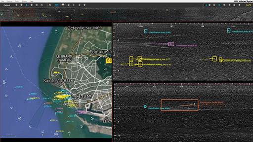
For decades, coastal security organizations have relied on wide area coverage technologies such as radar to detect suspect ships and other unauthorized visitors to their shores. These technologies still work, but they are increasingly being evaded by vessels with minimal radar signatures, such as small inflatable watercraft, wooden boats, and even drug traffickers on jet-skis. Detecting these threats “require ‘manual’ methods such as long-range cameras installed on the coast, on a ship or in an aircraft,” said Campana. “But these so-called ‘manual’ methods are mainly occasional, and their efficiency depends on operators’ skills. [This means that] Surveillance is limited [based on] on time and in a specific area.”
The ingenuity of human traffickers, drug smugglers and other maritime criminals are also adding to the challenge of effective border/shoreline control. They are “creating a constantly evolving challenge for coastal surveillance,” Latty said. “Drug smuggling, in particular, has shown worrying growth with organizations that are continuously innovating their methods such as the use of submarines. These semi-submersible and fully submersible vessels are capable of carrying several tons of illicit drugs, translating into billions of dollars in potential revenue for these cartels.” “Human trafficking is also on the rise as well as environmental crimes, such as the illegal dumping of waste and hazardous materials into the ocean, causing immense harm to marine ecosystems and posing a serious threat to maritime biodiversity,” he continued. “Illegal fishing is another growing concern: Over the past decade, instances of illegal fishing activities have surged, leading to the devastating destruction of marine habitats and drastically depleting fish populations. As an example, according to the 2020 WWF report, the illegal fishing market is estimated to be worth up to $23.5 billion per year, indicating its extensive scale.”
The bottom line: “All these increasing threats highlight the importance of developing and deploying more effective coastal surveillance methods and technologies,” said Latty. But that’s not all: “There is a real need for intelligence and automation to help operators increase the effectiveness of surveillance,” Campana said. “For land-based coastal surveillance, the difficulty lies in distinguishing people walking on the beach from illegal immigrants. Speed of detection is also crucial, so that the authorities act as quickly as possible before a tragedy occurs.“
Today’s Surveillance Solutions
As mentioned earlier, radar has been “a cornerstone of coastal surveillance” for decades, said Latty. Its precision and capabilities “have dramatically evolved” in that time, giving coastal security officials far more warning and data than was available in the past.
The Automatic Identification System (AIS) has also made a difference, with this shipboard transponder-based system transmitting key vessel data to other ships and shore-based stations on a real-time basis. “However, it is worth noting that AIS, being a collaborative system, can be intentionally deactivated, creating detection gaps,” Latty said.”This is where other surveillance assets come into play.”
One of these assets is electro-optical systems, which employ a mix of high-resolution cameras and infrared imaging. These systems are based on land and sea, in the air, and increasingly in space in the ever-increasing number of Earth observation satellites being put into orbit. “They are incredibly useful in such scenarios,” said Latty. “These systems not only validate the data derived from radar and AIS but also provide additional layers of information, which is crucial for effective surveillance.”
In the category of space-based camera systems, “Airbus is leveraging its full constellation of SPOT, Pléiades, and Pléiades Neo satellites, bringing detailed, almost real-time imagery of large maritime areas to the fingertips of coastal security personnel,” Latty noted. “Innovations in coastal surveillance technologies are swiftly being deployed to tackle evolving threats head-on.” Satellite technology forms the bedrock of these advancements, and Airbus’; Pléiades Neo satellites are the embodiment of this new generation. These satellites offer extraordinary enhancements in resolution, data transfer rates, and revisit times.
The enhanced resolution allows for more detailed imagery, enabling more precise identification and tracking of objects. By bringing their full constellation of SPOT and Pléiades satellites to bear, Airbus is now delivering more persistent and wide-ranging surveillance of vast maritime areas, bridging gaps in coverage and ensuring a more continuous and comprehensive monitoring capability,” Latty said. These coverage improvements are being boosted by quicker data transfer rates between these satellites and the ground, plus shorter revisit times that provide closer-to-real-time views on what is happening below.
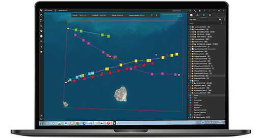
Factor Airbus’ suite of advanced image analysis algorithms into the mix, and this new system will be able to detect, identify, and track vessels across extensive oceanic expanses automatically. “The innovation here lies in the speed and accuracy of processing massive volumes of data,” noted Latty, “a task that once took image analysts days, now executed in mere minutes. And these cutting-edge solutions are not future aspirations; they are current realities. The technologies and analytics that Airbus has developed are already being utilized in several customer premises worldwide.”
Of course, technology plus collaboration is the key to successful coastal surveillance. This is why Airbus has designed its surveillance systems to support information sharing and coordination between various agencies across borders. “Such collaborative efforts ensure an integrated and efficient response to any maritime security threat,” said Latty. “Airbus’ role in the SPATIONAV program, the French state system for maritime information fusion, stands as a testament to the value of collaborative surveillance.”
Planning for the Future
The creativity of human traffickers, drug smugglers, and other threats to coastal security demand an ongoing response by surveillance solution providers. But keeping up with such hostile players isn’t just a matter of improving existing surveillance products and systems, it also requires using these products in new and better ways. This is why “new technologies often combine several sensors and surveillance vectors,” said Campana.
The downside: For these advanced surveillance solutions to perform as planned, “ensuring consistency between the different technologies is crucial,” he said. “Now deployed technologies can be temporary — surveillance vehicles, aircraft and patrols — or permanent; sensors installed on the top of towers, for example. [In either instance] The main challenge is to ensure that all these surveillance technologies are perfectly combined, enabling quick and efficient decisions.”
As well, the operators who control these solutions must be constantly retrained to keep their skills current and useful. According to Campana, “the operators behind the technologies remain essential, even if there is more and more automation. Speed of reaction is just as important as speed of detection.” In turn, this retraining regime “has to be planned in advance through a clear process answering some key questions like, ‘what human and material resources do we need? [And] How can we act while complying with the law?’”
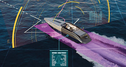
Nevertheless, advances in information technology are taking coastal surveillance solutions to the next level. Of these, Artificial Intelligence (AI) is proving to be a real revolution in this sector, by helping to significantly improve the automation of surveillance processes. For example, AI enables automatic alerts to be triggered by coastal surveillance systems when a specific hostile element like a certain kind of ship has been detected, while strongly reducing the number of false alerts at the same time.
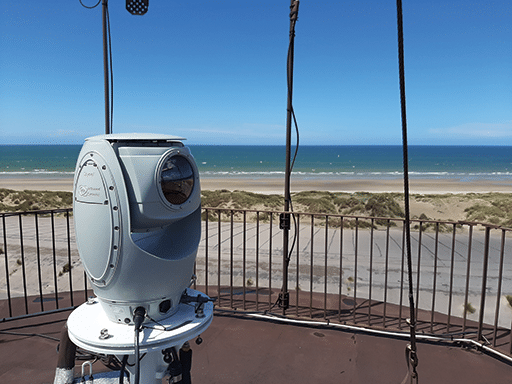
For instance, HGH’s AI-enabled SPYNEL thermal panoramic surveillance solutions offer 360° views to operators, while replacing up to 90 conventional PTZ [pan/tilt/zoom] cameras. “Our SPYNEL solution can automatically detect and classify very small stealth boats or groups of individuals on a beach, and continuously monitor an entire panorama, for real situational awareness,” said Campana.
Meanwhile, “Other coastal surveillance technologies can detect the presence of mobile phones at sea or used on the coast thanks to the radio waves they emit, or even via monitoring borders via satellite,” he said. “Integrating all these new technologies efficiently in order to save time in a user-friendly system remains a priority for HGH.”
Looking to the future of coastal surveillance technology, Airbus’ Latty said that the “advancement in tracking technology” is his company’s priority. “Next-generation trackers, offering superior real-time tracking capabilities, will enable us to locate and track vessels with unprecedented accuracy, even under challenging conditions,” he explained.
That’s not all: “The field of cybersecurity is another crucial area of focus,” continued Latty. “As our coastal surveillance systems become more advanced and interconnected, they also become potential targets for malicious cyber activities. Recognizing this, Airbus has its own cybersecurity business and expertise, delivering a comprehensive package of cybersecurity protections and services to safeguard our systems.”
Echoing Campana’s views, Latty also believes that “the rapid advancement in AI and Machine Learning (ML) is set to play a pivotal role in the future of coastal surveillance,” he said. “We anticipate these technologies will improve our ability to detect and identify vessels and activities significantly. These technological advancements will be supported by developments in computing power and data processing techniques, which will enable faster and more accurate analysis of data, leading to quicker response times and more effective decision-making.”
The Big Picture: The technology that makes coastal surveillance products and systems able to monitor coastlines today will become ever-more powerful and capable in the years to come. For security officials tasked with monitoring 372,000 miles of coastline, this is welcome news indeed!
